
Quick answer: Find your starting station and destination, match the line name or number, and identify any transfer station. Before boarding, compare the next station on your route with the platform signs. At your destination, check the numbered exit against the place you actually want to reach. Fares are distance-based: tap in at the start and tap out at the end with the same card.
Start with one short journey: Myeongdong to Anguk. You will learn how to read the Seoul subway map by finding two lines, one interchange and the stations between them. Then use the same checks for your own destination.
| Last updated | 21 September 2026 |
| Verification | Field tested (station signage) + App tested (NAVER Map) + Official-source verified |
| Location | Seoul, South Korea |
| Field tested | Sadang Station platform and exit signage, photographed 21 September 2026 |
| App tested | NAVER Map public-transport route search, Myeongdong to Anguk, September 2026 |
| Official sources | Seoul Metropolitan Government, Seoul Open Data Plaza, KRIC Railway Integrated Information System, Visit Seoul |
Start with this route: Myeongdong to Anguk
Trace the stations before choosing a train
Myeongdong → Chungmuro on Line 4; change to Line 3 → Euljiro 3(sam)-ga → Jongno 3(sam)-ga → Anguk.
Find these five stations on the map. Follow the light-blue Line 4 from Myeongdong for one stop, then switch to the orange Line 3 at Chungmuro. Count three more stops to Anguk. Counting stops helps you follow the route; it does not calculate the fare or include waiting time.
| Station | What to do | What to match |
|---|---|---|
| Myeongdong | Board Line 4 | Next station: Chungmuro |
| Chungmuro | Change to Line 3 | Next station: Euljiro 3(sam)-ga |
| Euljiro 3(sam)-ga and Jongno 3(sam)-ga | Stay on Line 3 | Anguk remains ahead |
| Anguk | Get off and choose your street exit | Your destination address |
Only change at Chungmuro. Euljiro 3-ga and Jongno 3-ga also connect with other lines, but your route stays on Line 3. A transfer symbol offers a connection; it does not instruct you to change.
Screenshot note: app screens in this guide were checked in September 2026. What you see can differ by app version, language setting and location.
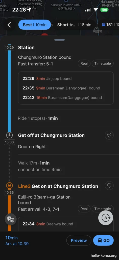
Read the next-station direction for each leg, then check the train destination. The screen also shows transfer-position guidance.
The detail screen makes the direction check concrete: Chungmuro Station bound appears for the first leg, while a train listing says Jinjeop bound. You are getting off at Chungmuro; you do not need to ride to the train’s final destination. For the second leg, look for Euljiro 3(sam)-ga Station bound and confirm the train serves Anguk.
You can plan a journey for another day without waiting for it. These screenshots were taken in the evening with the search set for the next morning, which is why the two kinds of time differ: the planned journey runs about 10:29–10:39, while the live arrival boxes show the trains running at that moment, around 22:29. Set your own travel date and departure time first, and read the live arrivals only when you are about to travel. The displayed duration and fare are examples, not a promise for your trip.
The screenshot labels 5-1 as a fast-transfer position: car 5, door 1. KRIC lists 5-1 and 7-1 for changing from Line 4 to Line 3 toward Euljiro 3-ga at Chungmuro, the direction used here. These are suggested positions for the connection, not compulsory places to board. If you are elsewhere on the train, get off at Chungmuro and follow the Line 3 transfer signs. KRIC Chungmuro station information
Match the platform, transfer and final exit
At Chungmuro, follow signs for Line 3. On the map, the direction toward Anguk proceeds through Euljiro 3(sam)-ga and Jongno 3(sam)-ga before reaching Anguk.
For the street-level step, choose an actual destination. For example, the Korea Tourism Organization lists Onion Anguk, 5 Gyedong-gil, near Anguk Exit 3. That makes Exit 3 a concrete example to compare with the destination map. It does not establish an accessible route or the best exit for every place in Bukchon. VISITKOREA destination directions
Plan your own journey with the map and an app
Turn your destination into a route, not just a station name
Search for the hotel, café, museum or other place you are visiting. Check the address before choosing it, especially when several businesses have similar names.
If you have not set up your app, follow our guide to using NAVER Map in English. Then request public transport directions from your actual starting location. If you normally use Google Maps, read why Google Maps does not give reliable directions in Korea first.
NAVER’s official help describes route sorting by recommended route, minimum time, minimum transfers and minimum walking. It also describes separate transport-mode results. These are useful comparisons when the fastest option is not the one you would find easiest with luggage. NAVER route-search help
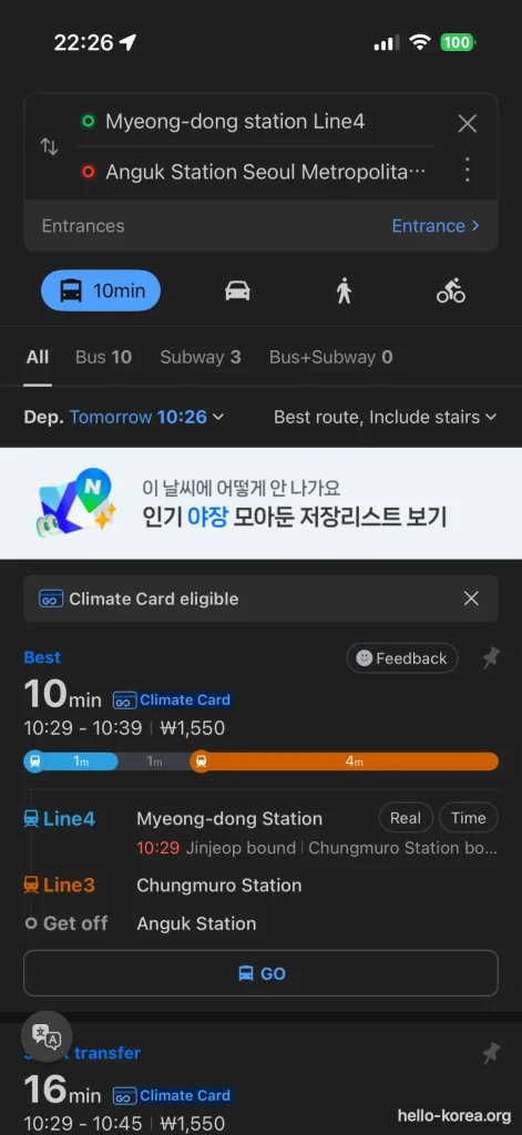
The route screen shows the two lines and the transfer station. Check the departure setting above the results before choosing a journey.
The selected filter also says Include stairs. If you need a step-free journey, this result alone does not establish one. Check the station access information for each part of your route.
Before the fare gate, prepare your ticket or funded transit card. If you need one, see how to buy and top up a T-money card. If you are staying a while and riding a lot, compare it with the Climate Card before you buy.
Choose between the official map and a journey planner
Use each tool for the question it answers best:
| Your question | Start with | Check next |
|---|---|---|
| Which lines connect these stations? | Official network map | Whether your journey requires a change |
| Which route should I take now? | Current public transport directions | Departure details and every connection |
| Am I on the correct platform? | Platform signs and the train display | Next station, direction and stopping pattern |
| Which way do I walk during a transfer? | Signs for your next line | Direction again when you reach its platform |
| Which exit gets me to the building? | Destination street map and station area map | Exit number and any access needs |
The official English map is available from Seoul’s Open Data Plaza. The English download listed when checked on September 20, 2026 was dated September 29, 2025. Use it to understand the network; check current directions for the journey you are about to make.
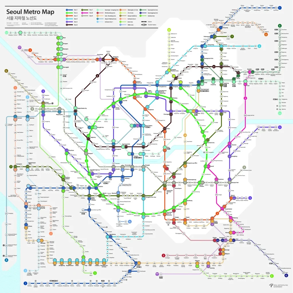
Map: Seoul Metropolitan Government / Seoul Metro, September 2025 edition, via Seoul Open Data Plaza. Resized for this guide; original available from the source linked above. KOGL Type 1.
The full map is dense on a phone. Download the original PDF or JPG if you want to zoom in on station names. The smaller image in this article is an overview, not a substitute for a readable route.
Read the map: line names, colours, station numbers and transfer symbols
Match the line name or number as well as its colour
Zoom into central Seoul and locate Myeongdong, Chungmuro and Anguk. Read the station names beside the line, then trace the connection with your finger. At Chungmuro, follow Line 3 toward Euljiro 3-ga. If your trace heads toward Dongguk University instead, you have followed the opposite direction.
On the official map, Line 2 is green, Line 3 is orange and Line 4 is light blue. Other services use names, such as the Airport Railroad and Gyeongui–Jungang Line. Do not expect every service to be identified by a single digit.

Match the line label as well as its colour. Legend cropped from the same official map; attribution as above.
Colour is a useful visual cue, but keep the name or number in your notes too. This makes it easier to check a small screen, a differently styled sign, or two colours you find hard to distinguish.
Station numbers identify stations; line numbers identify services; exit numbers identify ways to street level. Keep them separate when reading a sign. On this trip, “Line 3” tells you which train to take after the change, while “Exit 3” applies only to the final walk if it suits your destination.
Tell a transfer station from a simple line crossing
Look for the map’s interchange marking connecting the lines at a named station. Two lines crossing on the page do not, by themselves, tell you where to change trains.
The legend distinguishes ordinary stations from transfer stations. Confirm the station name at the connection, then check that your route actually asks you to change there.
An interchange symbol tells you about a rail connection. It does not tell you how many stairs or corridors you will use. Leave room in your plans for finding the next platform, especially when carrying a suitcase.
Seoul’s map-design guidance describes line colours, numbered stations and transfer markings as navigation aids. Designs have been introduced in phases, so concentrate on the information rather than expecting every sign to look identical. Seoul Metropolitan Government map-design guidance
Find the right platform and train
Compare the next station with your planned route
A direction label may show a station farther along the line rather than your stop. When the names do not immediately make sense, use the next station as your first cross-check, then confirm that the train continues along your required route.
Use this boarding checklist:
- Does the line name or number match?
- Is the next station in the direction you need?
- Does this train serve your destination or transfer station?
On Line 2’s loop, avoid choosing a direction simply because it seems to point toward your destination on the page. Compare the next station with the journey you selected. If the instructions mention the inner or outer circle and you are unsure, the named next stop gives you something concrete to match.
Check branches, destination displays and express/local service
Follow your route beyond the first stop. A line that splits on the map needs an extra check: which branch reaches your destination?
If your route or the display says express, inspect the stopping pattern. An express label is not enough to establish that it stops where you need to get off. Likewise, choosing a local service should still involve checking its direction and destination.
Change lines without following the wrong exit signs
Follow the next line’s transfer signs
At your transfer station, get off the train and look for signs identifying the line you need next. Follow those signs through the station, then repeat the direction check at the new platform.
Do not switch to following numbered street exits simply because they are prominent. You still need another train.
Visit Seoul’s passenger instructions tell riders to follow signs to the desired line when transferring. They also describe using a transport card at entry and at the destination exit gate. Official subway passenger guidance
Useful words to recognize include:
- 환승 — transfer
- 타는 곳 — boarding area or platforms
- 나가는 곳 / 출구 — way out or exit
- 방면 — toward
Open KRIC’s Chungmuro station information and select 기본정보 (basic information) for the layout or 빠른 환승정보 (fast-transfer information) for car and door suggestions. Use the diagram to orient yourself, then follow the station signs.
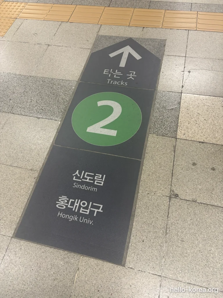
Read the line number before the arrow. In this Sadang Station photo, the green 2 identifies Line 2, and “Tracks” means the boarding area. Sindorim and Hongik Univ. are direction references on this sign. Match them to your planned journey before following the arrow; this is not an Exit 2 sign.
What to do when you encounter a transfer gate
Do not assume that seeing a gate means you have reached the street exit. First read the signs around it and check whether it belongs to your intended connection.
Follow the indicated ticket or card procedure. If the purpose of the gate is unclear, show your route to station staff before going through. Avoid repeatedly tapping different cards in an attempt to make it work.
You can show this question:
이 노선으로 환승하려면 어디로 가야 하나요?
“Where should I go to transfer to this line?”
If you tap out by mistake, Seoul’s 15-minute re-entry rule may save you the second base fare. Tap back in at the same station within 15 minutes with the same card, and the system applies a transfer instead of charging a new base fare. At an interchange you have to re-enter through the gates of the same line. It applies to prepaid and postpaid transit cards only, once per journey, and only on the sections Seoul lists (reference date 7 October 2023):
| Line | Section where the 15-minute re-entry applies |
|---|---|
| Line 1 | (Underground) Seoul Station – (Underground) Cheongnyangni Station |
| Line 3 | Jichuk Station – Ogeum Station |
| Line 4 | Jinjeop Station – Namtaeryeong Station |
| Line 6 | Eungam Station – Bonghwasan Station |
| Line 7 | Jangam Station – Onsu Station |
| Lines 2, 5, 8, 9, Ui–Sinseol Line, Sillim Line | All sections |
Outside those sections the rule does not apply: Line 1 towards Incheon or Suwon, Line 4 south of Namtaeryeong, the Airport Railroad and the Gyeongui–Jungang Line are all excluded. If you are unsure, ask staff before tapping. Sources: Seoul Metropolitan Government — subway, Seoul Metro passenger terms, Article 25.
Which car should I board for a faster transfer?
Korean rail operators publish, for every station, the car number and door number that put you closest to the transfer corridor or to the exit at your destination. Board there and you walk out ahead of the crowd instead of the length of the platform behind it. Almost no English-language guide mentions this.
Where to find the car and door numbers
The official source is the Railway Integrated Information System (철도 통합정보 시스템), run by the Railway Industry Information Center. Pick your region, line and station, then open the 빠른 환승정보 (fast transfer information) tab. The page is in Korean, but the part you need is numeric: an entry like 2번 칸 2번 문 means car 2, door 2. Cars are numbered from the front of the train in the direction of travel. Korean map and subway apps show the same positions inside route results, which is usually quicker than opening the site.
Worked example: Hongik Univ. Station, Airport Railroad to Line 2
This is one of the longer transfers in the system, long enough that a moving walkway is installed along the way. If you arrive from Incheon Airport with luggage, boarding position matters more here than almost anywhere else. The station’s official facility listing also shows lifts and escalators on every level, the moving walkway on B1, and coin lockers and toilets inside the paid area on B2.
| Transfer at Hongik Univ. | Board at |
|---|---|
| Airport Railroad → Line 2 (towards Hapjeong) | Car 2, Door 2 — or Car 5, Door 3 |
| Airport Railroad → Line 2 (towards Sinchon) | Car 2, Door 2 — or Car 5, Door 3 |
| Airport Railroad → Gyeongui–Jungang (towards Gajwa) | Car 2, Door 2 — or Car 5, Door 3 |
| Airport Railroad → Gyeongui–Jungang (towards Sogang Univ.) | Car 1, Door 4 — or Car 5, Door 3 |
These are suggested positions, not compulsory places to board. If you are elsewhere on the train, get off and follow the transfer signs as usual.
Are there toilets inside the fare gates?
Yes, station toilets are free, and the question that actually matters is whether yours is inside or outside the gates. If it is inside the paid area you simply walk to it. If it is outside, you have to tap out. That is what the 15-minute re-entry rule above is for.
The official station pages list this too. The entry reads 화장실 승강장 안 when the toilet is inside the platform area. Hongik Univ. Station on the Airport Railroad, for example, lists its toilet as inside the paid area.
This is not a trivial detail. When Seoul extended the re-entry window from 10 minutes to 15, one of the reasons it gave was that 51 of the 275 stations on Lines 1–8 have toilets more than 100 m from the gates.
Choose your exit before you leave the station
Check the street destination and numbered exit
Once you leave the train at your destination, open the saved place again. Compare the walking route with the station’s local-area map and numbered exits. For a meeting, agree on both the station and exit number, and whether to meet inside or outside.
Match a landmark to an exit number. This Sadang directory groups destinations beneath yellow exit labels. For example, “Sadang Post Office” appears beneath Exit 10. Find your destination in the directory, then compare its address with your walking directions. The number tells you which street exit to follow, not which train to board.
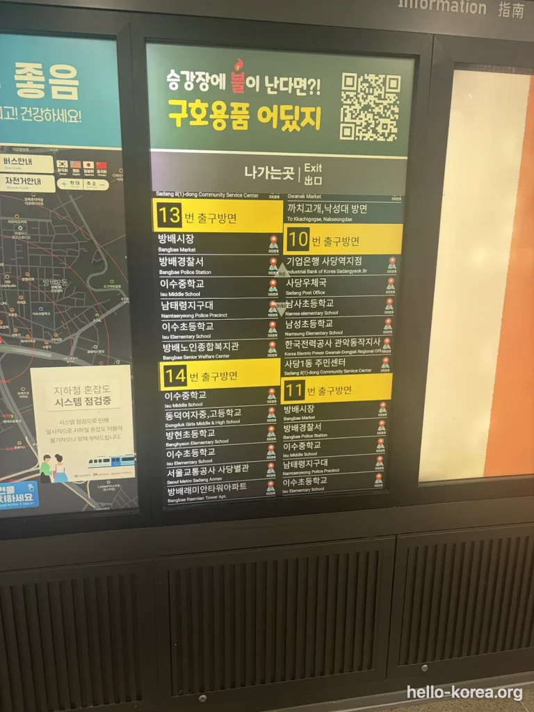
Check step-free access if you have luggage or mobility needs
A nearby exit and a suitable accessible route are two separate things to check.
Look for elevator signs and confirm the full path from your platform to street level. If you need to change lines, include the interchange in that check. Do not treat the presence of an elevator symbol somewhere in a station as confirmation of every connection you need.
Seoul provides a station accessibility-facilities listing. Use station information and staff assistance to confirm the route and any current disruption before relying on it.
A slightly different exit may be the practical choice. After using it, restart walking directions from that exit so the final leg matches your position.
Subway etiquette visitors get wrong
None of this is enforced by rule. It is what regular riders do, and visitors who ignore it are noticed immediately.
- Priority seats at the end of each car are left empty even when the train is full. Sitting in them is the most visible mistake a visitor can make.
- Phone calls are avoided. People text instead. Speakerphone and video calls without headphones stand out badly.
- Backpacks come off in a crowded car. Take yours off and hold it low, or wear it on your front, not on your back where you cannot see who it is hitting.
- Let passengers off first. Stand to the side of the doors, not in front of them.
- Eating is best avoided. Something small and odourless may pass unremarked, but anything with a smell will not, and not eating at all is the polite choice.
Common Mistakes—and how to recover
Wrong direction, missed stop or wrong branch
You boarded in the opposite direction. Get off at the next suitable stop and re-plan from that station. Look for the route to the other direction. If it appears to require leaving through a fare gate, ask staff before tapping out.
You missed your transfer. Stay calm and leave at the next stop. Search again from your current location rather than trying to force the original instructions to fit. Another route may be clearer than retracing every step.
You followed the right colour onto the wrong branch. Check where you are and where the train is going. Get off safely and obtain new directions. For the next boarding, check the destination display as well as the colour.
Take time to identify the next step; never rush through closing train doors.
Wrong exit, closed gate or a journey near the last train
You took the wrong street exit. Recalculate the walk from your actual position. Compare the street route with returning underground; do not assume retracing the station is necessary.
The gate does not let you through. Step aside, keep the same ticket or card ready, and ask staff to check the problem. Show your intended destination and explain whether you are entering, transferring or leaving.
You are travelling late. Check the whole journey, including the onward connection. A train arriving at your first station does not prove that you can complete a transfer afterward. Look up your travel date, direction and destination instead of relying on one “subway closing time.” Public holidays run a reduced timetable with wider gaps between trains than a weekday, which catches visitors out during Chuseok and Seollal in particular.
If rail service no longer gets you to your destination, check another available route or how to book a taxi in Korea. Confirm the destination and pickup point before requesting a car.
Your phone connection fails. Use your saved route, the station map and staff help. A downloaded network map can show connections, but it cannot tell you about a disruption that happened after you saved it.
FAQs
Where can I get an English Seoul subway map?
Use the official Seoul Open Data Plaza map listing and select the English PDF or JPG. Check the file’s edition date, not just the date on the surrounding webpage. Keep a readable copy on your phone.
Can I use the downloaded map offline?
Yes, a PDF or image saved on your device can be opened without a live map connection. Save the exact destination and journey details too. The file provides orientation; it does not update departure information, disruptions or changes to the network.
How do I choose a direction on Line 2?
Find the next station in your chosen route and match it with the platform information. Also check the train destination and any branch involved. Do not choose solely from the visual position of your destination on the loop.
Do I tap my card when changing lines?
No. A transfer between subway lines happens inside the paid area: follow the transfer signs and board the next train without tapping. A normal journey needs two taps, in at the start and out at the end, with the same card. Some interchanges between different operators have a separate transfer gate; tap the same card there and the journey still continues as one fare. If you cannot tell whether you are leaving the paid area, ask staff before you tap.
Is the fewest-transfer route always the easiest?
Not necessarily. Compare walking, connections and your access needs as well as the number of changes. NAVER offers minimum-transfer and minimum-walking sorting, but neither label alone verifies an accessible journey. Choose the route whose steps you understand.
Does the nearest numbered exit have a lift?
Do not assume so. Check the elevator route for your station and confirm how it connects with your platform. If a different exit suits your needs, use it and start the final walking directions from there.
Official sources
- 철도 통합정보 시스템 (Railway Integrated Information System): per-station fast-transfer car and door positions, exits, toilets, step-free routes and timetables
- Seoul Metropolitan Government — subway: fares, transfer discount, and the 15-minute re-entry sections by line
- Seoul Metro — passenger terms (Lines 1–8), Article 25: the re-entry conditions in the operator’s own tariff
- Seoul Open Data Plaza — official subway maps in four languages. KOGL Type 1
- Visit Seoul — subway passenger guidance
Leave a Reply